

India’s Land Slowly Slipping 5 to 6 Centimeters Beneath Tibetan Plate Per Year, raising concerns among scientists about the possibility of a devastating earthquake in the Himalayan region.
This slow movement, which measures around 5 to 6 centimeters per year, is a phenomenon that has been ongoing for millions of years and is now posing significant risks to the densely populated areas in northern India. While the tectonic forces are beyond human control, experts are urging the need for earthquake-resistant structures to minimize the impact of such natural disasters.
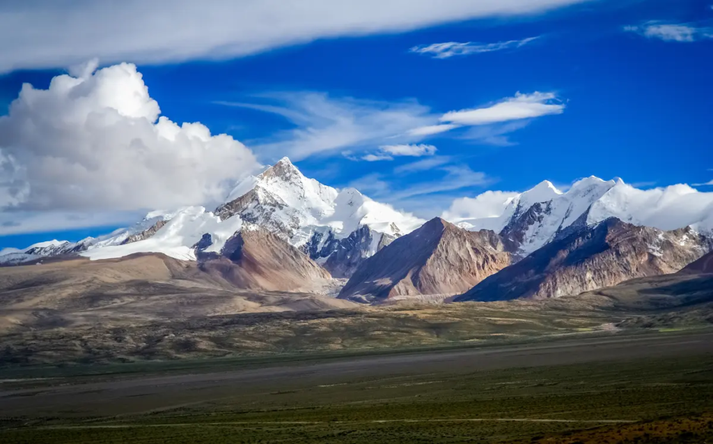
Tectonic Tug-of-War: The Indian and Tibetan Plates
The slow but constant movement of the Indian tectonic plate beneath the Tibetan plate is not a recent development; it dates back to the ancient geological phenomenon known as the continental drift. Approximately 60 to 70 million years ago, the Indian landmass was part of the supercontinent Gondwanaland, located near what is now Africa.
Due to the tectonic forces beneath the Earth’s crust, the Indian plate began moving northwards. For millions of years, the Indian plate drifted like a mobile island, slowly approaching the Eurasian landmass. Eventually, about 10 to 15 million years ago, the Indian plate collided with the Tibetan plate, giving rise to the Himalayan mountain range.
Read : World’s Tallest Mount Everest is Still Getting Taller
This geological collision has left a permanent mark on the region’s landscape, with the Himalayas still rising by about 5 millimeters each year. As the Indian plate continues to push beneath the Tibetan plate at a rate of 5 to 6 centimeters annually, it exerts enormous pressure on the Earth’s crust, which eventually releases in the form of earthquakes.
Read : Roof of the World: Exploring Tibet’s Top Must-Visit Destinations
The Himalayas, considered the youngest and most dynamic mountain range in the world, are a testament to this ongoing tectonic activity. The Indian plate’s subduction beneath the Tibetan plate is responsible for frequent seismic activity in the Himalayan region, which has already witnessed several devastating earthquakes. This process, described as a slow tightening of a rubber band, creates significant tension in the Earth’s crust.
When the tension reaches its breaking point, the ground shifts, causing earthquakes. Despite extensive research, predicting the exact timing and location of such seismic events remains a challenge, though scientists agree that the region is long overdue for a major earthquake.
Earthquake Risk in the Himalayan Region
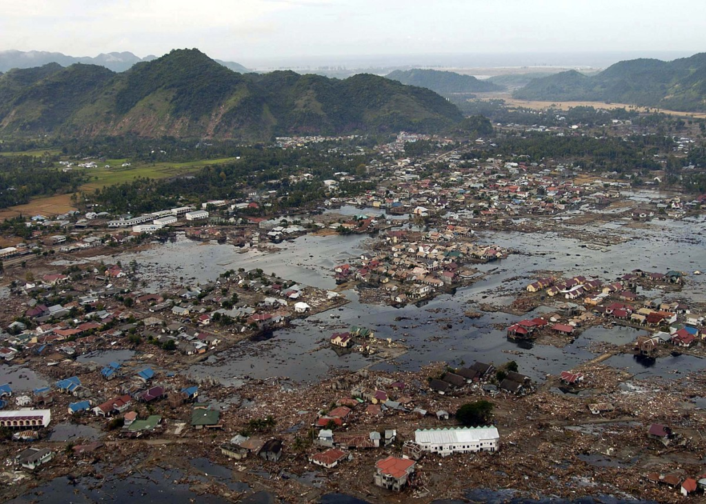
The Himalayan region has experienced a series of minor to moderate earthquakes over the years, but experts warn that a “mega-earthquake” could be imminent. Some parts of the region have not faced a massive earthquake in over 500 years, leading to concerns that the accumulated tectonic pressure could result in a catastrophic event.
The Indian subcontinent, particularly northern India, is vulnerable due to its proximity to the tectonic boundary between the Indian and Eurasian plates.
Scientists believe that the ongoing subduction of the Indian plate beneath the Tibetan plate will eventually result in a large earthquake, potentially devastating densely populated areas such as northern India, Nepal, and Bhutan.
The slow but relentless movement of the plates adds to the stress along the fault lines, increasing the likelihood of a significant seismic event.
The impact of such an earthquake would be far-reaching. In addition to the immediate destruction caused by ground shaking, secondary effects such as landslides, avalanches, and damage to infrastructure would pose additional risks. The region’s mountainous terrain, combined with its high population density, makes it particularly susceptible to the destructive forces of an earthquake.
While it is impossible to prevent earthquakes, scientists and engineers are working on strategies to mitigate the damage. Building earthquake-resistant structures and improving early warning systems are essential steps to protect lives and property in the event of a major seismic event.
Preparing communities for the possibility of a mega-earthquake through disaster preparedness programs and public awareness campaigns is also crucial.
The Role of Modern Science in Monitoring Tectonic Activity
To monitor the movements of the tectonic plates and assess the risks posed by the ongoing subduction of the Indian plate, Indian scientists have set up a series of high-accuracy reference stations.
These stations, located at Hanle in Ladakh on the Tibetan plate and in Bengaluru on the Indian plate, use sophisticated global positioning system (GPS) instruments and satellites to track the plates’ movements.
According to Dr. Sridevi Jade, Director of the CSIR Fourth Paradigm Institute (CSIR-4PI) in Bengaluru, the land at Hanle has moved approximately 85 centimeters northeastwards over the last 25 years, while Bengaluru has moved by about 1.37 meters. This movement is evidence of the continued tectonic activity in the region and highlights the stress building along the fault lines.
Dr. Jade and her team use this data to better understand the mechanics of continental drift and the potential risks posed by the tectonic activity in the Himalayan region. By tracking the relative movements of the Indian and Tibetan plates, they can assess how much tension is building up in the Earth’s crust and identify areas where a future earthquake might occur.
While scientists cannot predict the exact timing of an earthquake, the data collected through these monitoring stations provides valuable insights into the tectonic forces at work beneath the surface. This information is crucial for improving earthquake preparedness and designing structures that can withstand the forces of a seismic event.
The research conducted by CSIR-4PI is part of a broader effort to better understand the complex interactions between the Earth’s tectonic plates and the potential risks they pose to human populations.
By studying the movements of the Indian and Tibetan plates, scientists hope to improve our ability to predict and respond to earthquakes, ultimately saving lives and reducing the impact of these natural disasters.
The ongoing tectonic activity in the Himalayan region is a reminder of the powerful forces shaping our planet. The slow but steady subduction of the Indian plate beneath the Tibetan plate has been happening for millions of years, and it will continue for millions more.
However, the human consequences of this geological process are becoming increasingly evident, as scientists warn of the potential for a devastating earthquake in the region.
While we cannot stop tectonic activity, we can take steps to protect ourselves from its effects. Building earthquake-resistant structures, improving early warning systems, and raising public awareness about the risks of living in an earthquake-prone region are all critical measures that can help reduce the impact of a future seismic event.
The tug-of-war between the Indian and Tibetan plates is a natural process that has been shaping the Earth’s landscape for millions of years. But as scientists continue to study this phenomenon, they are also working to ensure that the people living in the region are better prepared for the challenges it poses. By understanding the risks and taking proactive measures, we can minimize the damage caused by earthquakes and protect the communities most at risk.