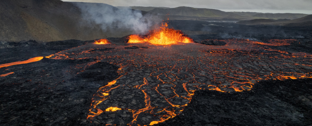
In a spectacular display of nature’s power, NASA’s Landsat 9 has captured a stunning Satellite Image of Fiery Lava Flowing from the latest volcanic eruption in Iceland.
The photograph reveals glowing red-hot streams oozing from a fissure on the Reykjanes Peninsula, a region that has witnessed unprecedented volcanic activity over the past year.
This eruption has not only fascinated scientists but also raised significant concerns for local communities and iconic landmarks like the famous Blue Lagoon.
Unrelenting Volcanic Activity on Reykjanes Peninsula
The latest eruption, which began on November 20, is the seventh recorded in the Reykjanes Peninsula within a year. Prior eruptions started on August 22, May 29, March 16, February 8, and January 14 of this year, as well as December 18, 2023.
This frequency is highly unusual, even in a volcanic hotspot like Iceland, and has left scientists scrambling to understand its long-term implications.
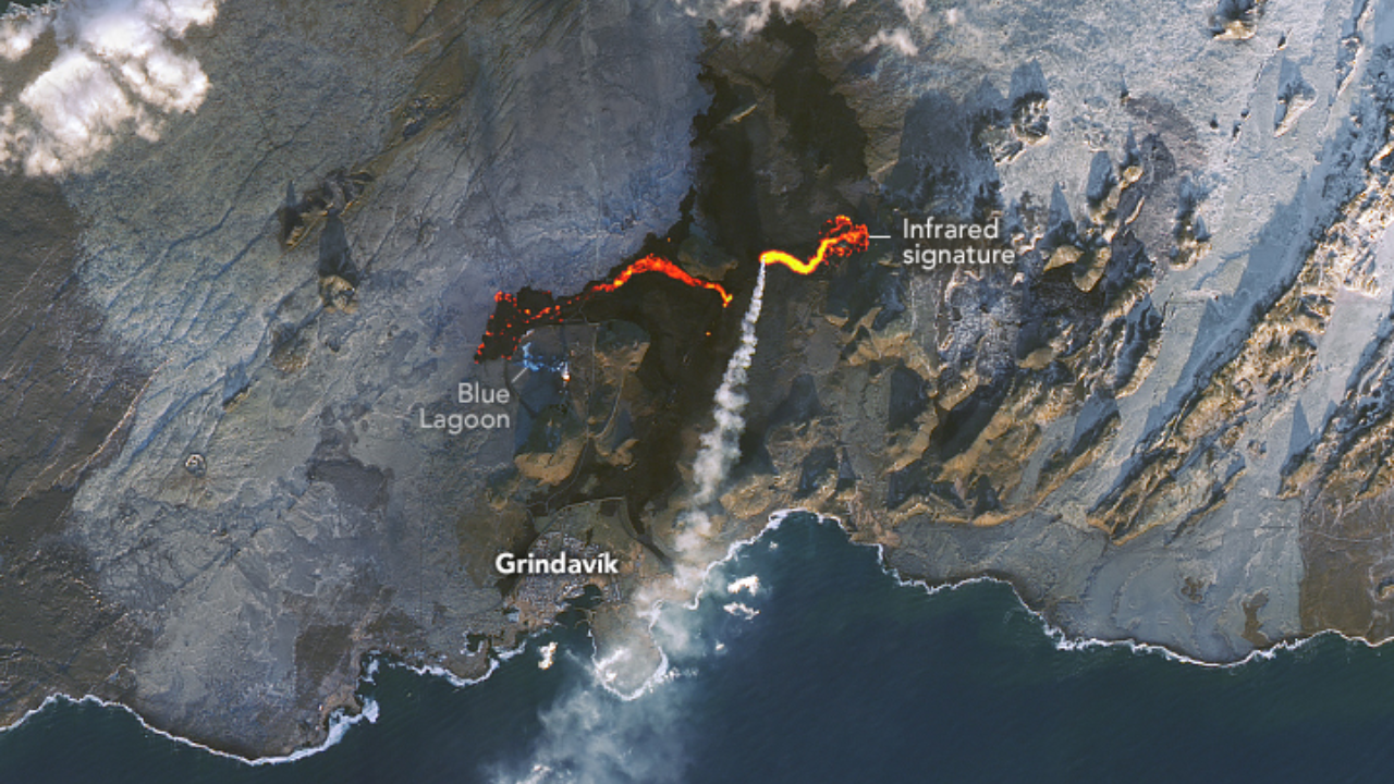
Captured from space by the OLI-2 (Operational Land Imager-2) on Landsat 9, the image shows a vivid red streak marking the 1.8-mile fissure near Stóra Skógfell peak.
This fissure lies northeast of Grindavík, a town of 3,800 residents that has been repeatedly evacuated due to the eruptions. This eruption follows a pattern similar to the February 2024 event, threatening infrastructure and livelihoods, with lava ultimately reaching and consuming the Blue Lagoon’s parking lot.
Read : Kilauea Volcano in Hawaii Experienced a Seismic Swarm with 30 Earthquakes Per Hour
While Icelandic authorities had evacuated the lagoon and surrounding homes well in advance, the speed and intensity of this eruption were notable. “The current eruption’s lava flow is comparable to the most powerful eruptions in Fagradalsfjall,” according to the Icelandic Meteorological Office.
At its peak, the lava flow was around 1,300 cubic meters per second—a significant force, though less than the 2,500 m³/s rate recorded in August.
Geological Dynamics Behind the Eruption
This recent eruption belongs to the fissure eruption category, characterized by lava emerging from elongated cracks rather than a central volcano. Rachel Beane, a professor at Bowdoin College, explained: “A fissure is a fracture through which a sheet of magma flows. When this fracture intersects the surface, it allows lava to erupt onto the ground.”
Beneath the surface, magma travels through conduits known as dikes, sometimes extending several kilometers horizontally.
This eruption’s stability and prolonged activity have puzzled geologists. Unlike previous instances, seismic activity did not increase in the weeks leading up to the eruption.

This absence of warning signals has made it more challenging to predict the exact timing and scale of these events. The Icelandic Meteorological Office emphasized the anomaly, noting that “the eruption has remained stable for 24 hours with lava flowing east toward Fagradalsfjall.”
Experts are now considering the possibility that this volcanic cycle could last for decades or even centuries. David Pyle, a professor at the University of Oxford, pointed out, “The last time we saw this kind of activity, it persisted for decades. This is a slow release of accumulated strain as the American Plate and the Eurasian Plate pull apart.”
The potential for underwater eruptions adds another layer of concern, as they could trigger more violent and unpredictable events.
Impact on Communities and Infrastructure
The relentless volcanic activity poses a significant threat to Icelandic communities, particularly those near Grindavík. This town has faced repeated evacuations, with some eruptions burning homes on the outskirts. The psychological toll on residents has been immense, as they must remain prepared for sudden evacuations and potential loss of property.
The Blue Lagoon, one of Iceland’s most famous tourist attractions, has also suffered. Known for its geothermal spa and otherworldly landscapes, the lagoon draws visitors from around the globe.
The encroaching lava has damaged parts of its infrastructure, including its parking area, and forced temporary closures. For a country heavily dependent on tourism, such disruptions can have broader economic impacts.
Despite these challenges, Iceland’s authorities have demonstrated remarkable resilience and preparedness. Their proactive measures, including timely evacuations and continuous monitoring, have minimized casualties and ensured that vital infrastructure remains protected.
However, as volcanic activity continues, long-term strategies will be crucial. Scientists and government agencies must work together to develop more accurate prediction models and strengthen disaster response frameworks.
The Broader Implications for Volcanic Monitoring
The images captured by NASA and other satellites play a critical role in monitoring volcanic activity and assessing potential risks. The OLI-2 on Landsat 9 and the VIIRS on the Suomi NPP satellite provide invaluable data that allow scientists to track lava flows and heat signatures in real-time. These technological advancements enable better predictions and more effective disaster management strategies.
In this instance, the VIIRS captured the eruption’s heat signature, which shone brighter than Reykjavík, Iceland’s capital. Such data helps authorities understand the eruption’s intensity and direction, facilitating timely evacuations and resource allocation.
Satellite imagery also contributes to global research efforts, as scientists can analyze patterns and compare data across different volcanic regions. The Reykjanes Peninsula’s recent activity offers insights into plate tectonics and magma dynamics, which could improve our understanding of volcanic behavior worldwide.

As Iceland continues to grapple with ongoing eruptions, the focus must be on long-term preparedness and resilience. Experts predict that this volcanic cycle may last for decades, raising questions about the sustainability of current evacuation and infrastructure protection measures.
The possibility of underwater eruptions adds another layer of complexity, as such events could have more violent and far-reaching consequences.
The international scientific community will play a crucial role in supporting Iceland’s efforts. Collaborative research, advanced monitoring technologies, and shared expertise can help develop more robust prediction models. For Iceland, this means balancing short-term safety measures with long-term strategies to protect its communities and critical infrastructure.
In the face of nature’s relentless power, Iceland’s response serves as a model of resilience and preparedness. The stunning images captured by NASA remind us of both the beauty and the danger of our planet’s dynamic forces, highlighting the importance of vigilance and innovation in the face of natural disasters.