The world is full of fascinating and unusual landforms, some of which are so remote and unique that they remain undiscovered for centuries.
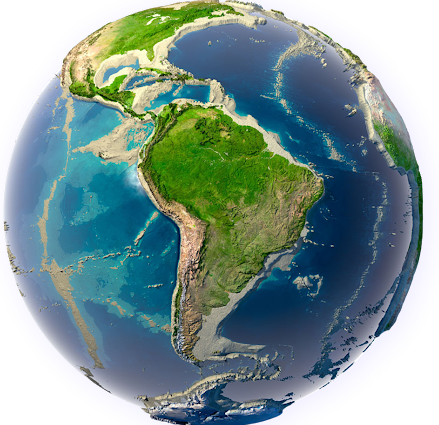
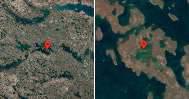
One such remarkable geographical feature is an island located within Victoria Island in Canada’s Nunavut Territory. This nameless island holds a rare distinction—it is the World’s Largest Island within a lake, which is on an island, inside another lake, and again on an island.
Recently confirmed through satellite imagery by the Operational Land Imager (OLI) on Landsat 8, this incredible landform has now been officially recognized by Guinness World Records.
World’s Largest Island Within a Lake
The island, which remains unnamed, is an extraordinary example of what geographers call “recursive islands and lakes.” At its core is a seahorse-shaped island that spans approximately 1,000 feet in width. This island is surrounded by a small, isolated lake. However, the complexity does not end there.
This lake is itself located on a larger island, which sits within yet another lake—this time a much bigger, finger-shaped body of water. The entire formation is situated about 90 kilometers inland from the southern coast of Victoria Island, a vast landmass that is already one of the most intriguing locations in the Canadian Arctic Archipelago.
Read : Is Santorini Island at Risk of Erupting After a Series of Earthquakes?
Victoria Island, also known as “Kitlineq” by the Inuit, is the eighth-largest island in the world, covering an area of approximately 217,291 square kilometers.
Read : Jeju Island: A Serene Haven of Natural Wonders and Cultural Delights
It is a place of harsh Arctic climate, marked by a frozen landscape for much of the year, with vast tundra, icy lakes, and countless small islands dotting its shores. Given the sheer size and remoteness of the region, it is not surprising that such an unusual landform remained hidden from human knowledge until recently.
The use of satellite imagery has played a crucial role in the discovery of this unique location. The Operational Land Imager (OLI) on Landsat 8 captured detailed images that confirmed the existence of this landform.
The clarity of these images allowed geographers and scientists to analyze the intricate layers of islands and lakes, revealing a rare natural phenomenon. The recognition by Guinness World Records further highlights its uniqueness, solidifying its place in geographical history.
The Unexplored Canadian Arctic and Its Hidden Wonders
The Canadian Arctic is one of the least explored regions in the world. Unlike other parts of the planet where human presence is widespread, much of this vast, frozen wilderness remains untouched. The region is characterized by thousands of islands and millions of lakes formed as a result of the last Ice Age.
Glaciers that once covered this landscape carved deep depressions in the land, which later filled with water as the ice receded. This process created a unique topography where lakes and islands are intricately interwoven.
Given the extreme remoteness of the island-in-a-lake-on-an-island-in-a-lake-on-an-island, it is highly likely that no human has ever set foot on it. The harsh Arctic conditions make travel to such locations incredibly difficult.
The presence of permanent ice cover, freezing temperatures, and lack of accessible transportation routes means that exploration in this part of the world remains a challenge.
Unlike tropical islands or mountainous landscapes that are more accessible to researchers and adventurers, the Canadian Arctic requires specialized equipment and logistical support to navigate.

Despite these challenges, modern technology has allowed scientists to explore these regions from afar. Satellite imagery, aerial surveys, and remote sensing techniques have proven to be invaluable tools in mapping and studying the Arctic landscape.
These advancements have made it possible to identify unique geographical features that would otherwise go unnoticed. The recent confirmation of the island-in-a-lake-on-an-island-in-a-lake-on-an-island is a testament to the power of these technologies in uncovering the hidden wonders of our planet.
Beyond this specific landform, the Canadian Arctic likely harbors many more undiscovered islands, lakes, and unusual geological formations. As technology continues to improve, more such discoveries may come to light, further enhancing our understanding of this remote and fascinating region.
The possibility of finding similar or even more complex landforms adds to the excitement of Arctic exploration, demonstrating that Earth still holds many secrets waiting to be uncovered.
Other Unusual Islands and Disappearing Landforms
While the island-in-a-lake-on-an-island-in-a-lake-on-an-island is a truly exceptional landform, it is not the only unusual island discovery in recent history. Around the world, various remarkable islands have been identified, each with its own unique characteristics.
For instance, NASA satellites have observed the formation and disappearance of temporary islands off the coast of Azerbaijan in the Caspian Sea. In early 2023, a new island emerged due to an eruption from the Kumani Bank mud volcano.
The volcanic activity created a landmass that stood above the water’s surface for nearly two years before it was completely eroded by the end of 2024. The rapid formation and disappearance of such islands highlight the dynamic nature of Earth’s geological processes.
Volcanic islands are not uncommon, and history is filled with examples of landmasses that have appeared suddenly due to eruptions, only to be washed away by ocean currents and erosion over time.
One well-known example is the island of Surtsey, which emerged off the coast of Iceland in 1963 due to an undersea volcanic eruption. Unlike the Kumani Bank island, Surtsey has remained intact and continues to be studied by scientists as a unique natural laboratory for ecological succession and island formation.
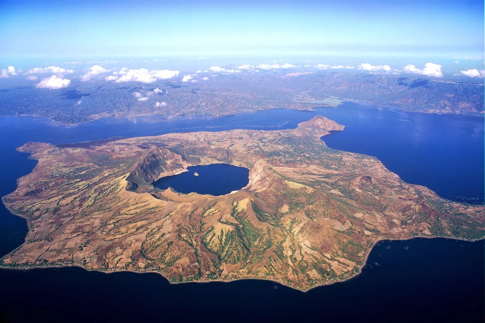
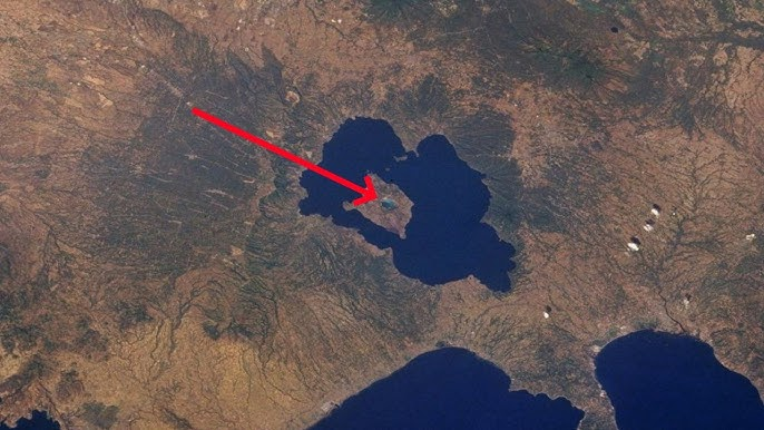
In addition to volcanic islands, there are also examples of recursive islands and lakes in other parts of the world. One well-documented case is the “island-in-a-lake-on-an-island” within the Philippines’ Taal Volcano.
Taal is known for its crater lake, which contains Volcano Island, and within this island is another lake, home to its own small island. While not as complex as the newly discovered landform in Canada, it remains a striking example of nature’s ability to create layered geographical features.
The discovery of the world’s largest island-in-a-lake-on-an-island-in-a-lake-on-an-island adds another fascinating chapter to the study of Earth’s diverse landscapes. It showcases the intricate and sometimes unexpected ways in which land and water interact, creating formations that defy simple categorization.
As mapping technologies and satellite observations continue to improve, the possibility of discovering even more unique landforms remains high. Whether in the Arctic, the tropics, or beneath the ocean’s surface, Earth’s geography is a constantly evolving puzzle that continues to surprise and inspire those who seek to understand it.