
Modern navigation technology has transformed transportation and logistics, enabling drivers to reach destinations with unprecedented ease and efficiency. Yet the reliance on digital mapping systems can sometimes create unexpected risks, particularly in environments where geography, history, and natural hazards intersect. A recent incident along England’s eastern coastline highlights this reality vividly.
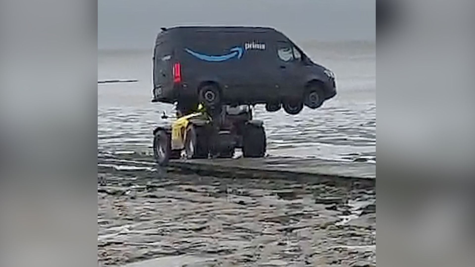
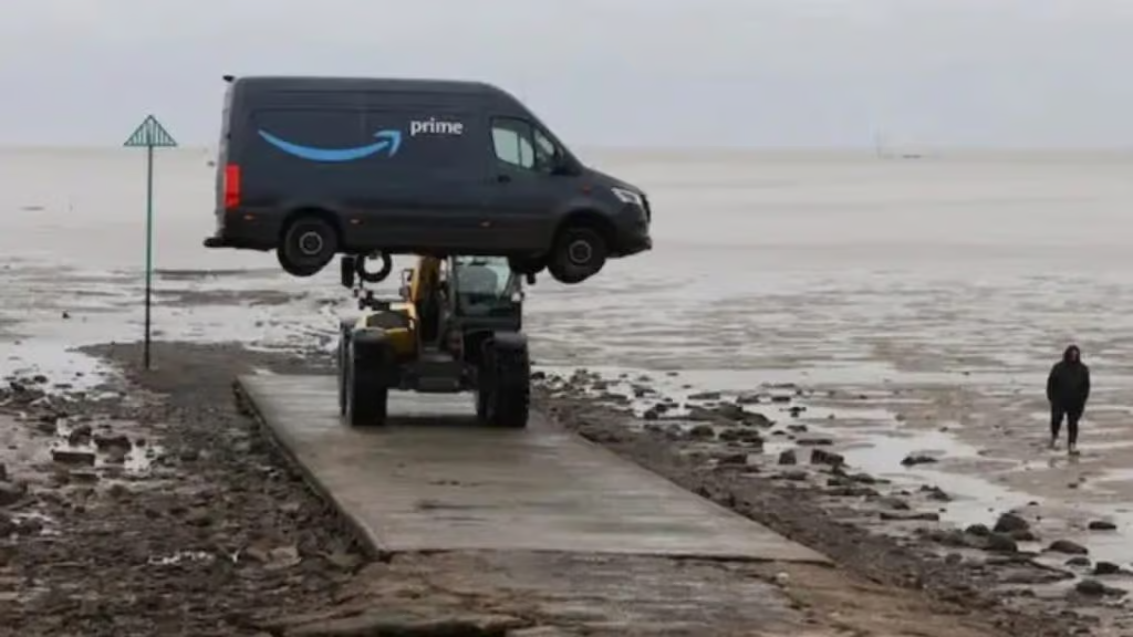
An Amazon delivery van became stranded after its driver followed a GPS route onto the Broomway, an ancient and notoriously dangerous pathway across tidal mudflats. What began as a routine delivery journey turned into a cautionary episode involving emergency monitoring, vehicle recovery, and renewed attention to the dangers of navigating unfamiliar terrain solely through digital guidance.
The incident unfolded near Foulness Island off the coast of Essex, where the Broomway stretches across shifting sands and mudflats that have long been regarded as treacherous even for experienced walkers. Despite its centuries-old existence, the route is not intended for motor vehicles and is subject to strict access conditions due to environmental hazards and nearby defense operations. The stranded van, immobilized by deep mud and tidal conditions, became an example of how technological convenience can sometimes override practical awareness, with potentially serious consequences.
The Broomway’s Perilous Geography and Historical Reputation
The Broomway is far from an ordinary coastal path. Extending roughly six miles across tidal flats, it has existed for centuries as a narrow route used historically by locals traveling between the mainland and Foulness Island. Its name is believed to derive from broom markers that once indicated the safest passage across the shifting landscape. Even with these markers, the route has never been considered safe without experience, preparation, and precise timing in relation to tides.
The terrain itself presents multiple hazards. Much of the pathway lies across soft mud that can trap both people and vehicles with alarming speed. The consistency of the ground varies dramatically, and what appears firm from a distance may collapse under weight. This instability makes movement difficult and unpredictable, especially for those unfamiliar with the landscape. Unlike paved roads or even typical footpaths, the Broomway offers little visual clarity about safe footing, making navigation challenging even in good conditions.
Compounding the danger is the behavior of the tides in the surrounding estuary. Water can rise rapidly and sometimes from unexpected directions, cutting off escape routes and submerging large sections of the path. The speed of tidal change is one of the primary reasons the Broomway has gained a grim reputation over the years. Historical records have linked numerous drownings to misjudgments about timing and direction, contributing to its description as one of Britain’s most dangerous footpaths.
Read : Liz O’Brien’s Dog Brutally Kicked by Amazon Delivery Driver Caught on Camera
In addition to natural hazards, parts of the surrounding area have been used for military testing. Straying from designated routes carries the theoretical risk of encountering unexploded ordnance, further reinforcing the need for specialist knowledge and guided access. Because of these combined dangers, authorities strongly advise that anyone attempting to cross the Broomway do so only with experienced guides who understand the terrain, tidal schedules, and safe navigation points.
Read : Farmers of Nazca Found ‘Alien Mummies’ in Cave of Peru
Against this backdrop, the presence of a motor vehicle on the mudflats represents a significant deviation from established safety practices. Vehicles are particularly vulnerable because of their weight and limited maneuverability once traction is lost. Even slight miscalculations can result in rapid immobilization, leaving drivers exposed to environmental risks while awaiting assistance.
How GPS Misdirection Led to the Stranding
The delivery driver involved in the incident was reportedly attempting to reach Foulness Island when the navigation system directed the vehicle toward the Broomway. From a digital mapping perspective, the route may appear as a direct connection across the landscape, potentially interpreted as a passable track. However, mapping systems do not always distinguish between paths that are theoretically accessible and those that are practically or legally safe for vehicles.
Such discrepancies arise for several reasons. Mapping data often relies on satellite imagery, historical records, and user-generated information, which may not accurately reflect real-time conditions or restrictions. A path visible from above may be classified simply as a route, without contextual details about tides, surface stability, or regulatory limitations. When drivers follow turn-by-turn navigation without independent verification, they may unknowingly enter environments that are unsuitable for vehicles.
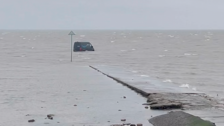
In this case, the driver followed the digital directions onto terrain that gradually became impassable. Once the van reached the mudflats, its weight caused it to sink into soft ground, eliminating the possibility of driving out without external assistance. The situation quickly became less about navigation and more about safety, as changing tides and environmental exposure posed potential risks.
Emergency services were alerted after the vehicle became stranded. The primary concern for responders was not the van itself but the safety of the driver and any potential environmental impact. Once authorities confirmed that the driver had exited the vehicle safely and that recovery arrangements were underway, their direct involvement was limited. The responsibility for extracting the van fell to the vehicle’s operators, who arranged for a local farmer to assist with removal.
This sequence of events illustrates how rapidly a navigation error can escalate into a complex logistical situation. What might appear as a minor misdirection on a map can lead to immobilization in hazardous terrain, requiring coordination between private recovery services and emergency monitoring agencies.
Safety Lessons and Broader Implications of Digital Navigation Dependence
The stranding of the delivery van has drawn renewed attention to the limitations of GPS-based navigation, particularly in environments where natural conditions change frequently. While digital mapping has become an indispensable tool in modern logistics, it is not infallible. Systems are designed to optimize efficiency, often prioritizing the shortest or fastest route, but they may lack contextual awareness of local hazards or restrictions.
Drivers operating in unfamiliar regions face particular vulnerability. Without prior knowledge of local geography, it is easy to assume that a suggested route is both accessible and safe. However, coastal environments, rural tracks, and restricted zones often require specialized knowledge that cannot be fully captured by automated systems. The Broomway exemplifies a location where physical reality diverges sharply from digital representation.
Read : Isharae Jackson Sues Amazon Over Alleged Harassment for Pumping Breast Milk at Fulfillment Center
The incident also underscores the importance of signage, local guidance, and regulatory enforcement in hazardous areas. Where dangerous paths exist, clear warnings and physical barriers can help prevent accidental entry. In areas connected to sensitive operations, such as defense ranges, access restrictions serve both safety and security purposes. Ensuring that such measures are visible and unambiguous is essential to reducing the likelihood of similar events.
For delivery services and other logistics providers, the episode highlights the need for operational protocols that account for navigation uncertainties. Drivers may benefit from training that emphasizes independent assessment of routes, particularly when approaching remote or unusual terrain. Cross-referencing navigation instructions with local knowledge, posted warnings, or company guidelines can help prevent risky decisions based solely on digital directions.
From a broader perspective, the situation reflects a growing tension between technological convenience and environmental awareness. As navigation systems become more sophisticated, users may become less inclined to question their accuracy. Yet natural landscapes, especially those shaped by tides, weather, and geological change, resist precise digital modeling. Human judgment remains an essential component of safe navigation, particularly in areas where conditions evolve continuously.
The recovery of the stranded van ultimately concluded without reported injuries, and the driver was confirmed to be safe. Nevertheless, the event serves as a reminder of how quickly routine activities can intersect with hidden dangers when technology and environment misalign. Coastal mudflats, ancient pathways, and restricted zones do not adapt to digital assumptions, and even advanced navigation systems cannot fully replace situational awareness.
The Broomway continues to stand as a landscape where history, nature, and hazard converge. Its long record of incidents and its reputation as a perilous crossing remain unchanged despite modern technology. The recent stranding of a delivery vehicle adds another chapter to that history, reinforcing the enduring lesson that some places demand respect, preparation, and knowledge that extend beyond what any screen can provide.