
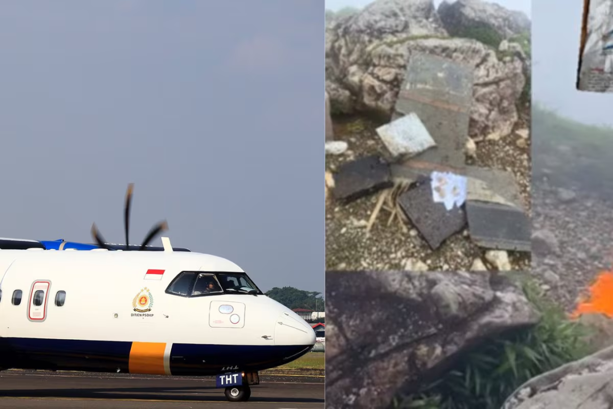
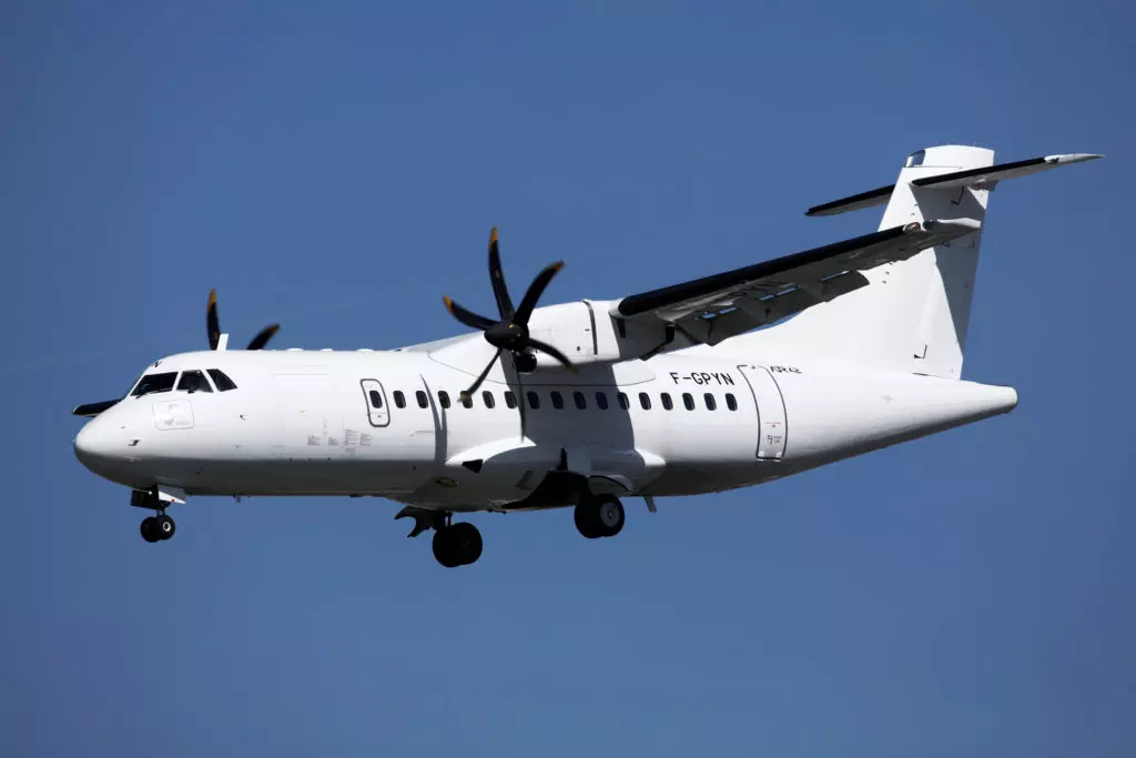
A regional passenger aircraft carrying 11 people vanished from radar in Indonesia on Saturday, triggering a large-scale search-and-rescue operation in one of the country’s most challenging terrains. The turboprop ATR 42-500, operated by Indonesia Air Transport, was flying a chartered mission from Yogyakarta to South Sulawesi when contact was lost while the aircraft was approaching its destination.
Authorities confirmed that the plane disappeared near the mountainous Bulusaraung area in Maros district, a region known for steep limestone formations, dense forest cover, and limited ground access. As rescue teams race against time, officials are working to verify unconfirmed reports of debris and to establish what may have caused the aircraft to deviate from its intended flight path.
The aircraft was carrying eight crew members and three passengers, all identified as officials from Indonesia’s Ministry of Marine Affairs and Fisheries. The ministry later confirmed that the flight had been chartered for operational purposes, with the passengers reportedly conducting air surveillance related to fisheries management. While Indonesia has extensive experience handling aviation incidents across its vast archipelago, the disappearance of this aircraft has once again highlighted the unique operational risks associated with flying over remote and mountainous regions.
Disappearance During Final Approach Over Rugged Terrain
According to Indonesia’s aviation authorities, the ATR 42-500 was proceeding normally for most of its journey before encountering difficulties during its approach phase into South Sulawesi. The aircraft was last tracked at approximately 1:17 p.m. local time in the Leang-Leang area of Maros, which lies close to Bulusaraung National Park. This region sits between the Maros and Pangkep districts and is characterized by sharp elevation changes that require precise navigation during low-altitude flight.
Endah Purnama Sari, a senior aviation official, said that air traffic controllers had instructed the pilots to correct their approach alignment as they prepared to land at Sultan Hasanuddin International Airport. Shortly after these instructions were issued, radio contact with the aircraft was lost. Controllers subsequently declared an emergency distress phase, a standard procedure when an aircraft fails to respond during a critical stage of flight.
The ATR 42-500 is a widely used regional turboprop aircraft designed for short-haul routes and capable of carrying between 42 and 50 passengers. It is commonly deployed on routes serving smaller airports and challenging environments, including mountainous and island regions. While the model has a strong operational record, approach phases in areas like South Sulawesi demand strict adherence to flight paths due to rapidly rising terrain and limited margins for error.
Officials believe the aircraft may have deviated from its assigned approach corridor and entered mountainous terrain near Bulusaraung National Park. The area’s limestone peaks and forested slopes can rise sharply, creating potential hazards if an aircraft descends below safe altitude. While no definitive cause has been established, investigators are expected to examine factors such as navigation accuracy, terrain awareness systems, and operational decision-making once more information becomes available.
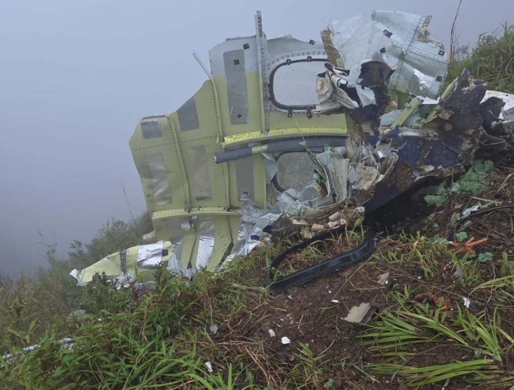
Indonesian authorities found debris from a plane that went missing with 11 people onboard, state news agency ANTARA reported.
— TRT World (@trtworld) January 18, 2026
The Indonesian Air Force said the crash site was identified in the Mount Bulusaraung area of South Sulawesi province and that a rapid response team was… pic.twitter.com/1I5l5wyi0J
Weather conditions at the time of the disappearance were reported to be relatively stable. Authorities noted cloud cover with visibility of around eight kilometers, and no severe weather warnings had been issued for the region. This has led officials to caution against premature conclusions, emphasizing that the investigation will need to consider a range of technical and operational variables before determining what went wrong.
Search-and-Rescue Efforts Intensify in Bulusaraung Area
Following the loss of contact, Indonesian authorities launched an extensive search-and-rescue operation involving multiple agencies. Teams from the national search and rescue agency were deployed alongside Indonesian air force helicopters, drones, and ground units. The primary focus has been on the Bulusaraung area, where the aircraft was last detected and where unconfirmed reports of debris have emerged.
The terrain has posed significant challenges to rescue teams. Bulusaraung National Park is known for its steep slopes, dense vegetation, and limited road access, all of which complicate ground operations. Rescue officials said that reaching suspected locations on foot could take several hours or longer, depending on weather and visibility conditions. Aerial searches, while faster, are constrained by cloud cover and the need to fly cautiously over rugged topography.
Read : 80-Year-Old Man Arrested at Tenerife South Airport After Trying to Wheel Dead Wife Onto Plane
Hopes of locating the aircraft rose after hikers on Mount Bulusaraung reported seeing scattered debris and small fires burning in the area. Some of the debris was described as bearing markings consistent with the airline’s logo. These reports are currently being verified by rescue teams attempting to access the site. Bangun Nawoko, the Hasanuddin military commander for the region, said that teams are moving carefully to confirm the findings while ensuring their own safety in the difficult terrain.
Authorities have emphasized that search operations will continue through the night and into Sunday, with priority given to confirming the debris reports and locating any possible survivors. Night operations in mountainous forest areas are inherently risky, but officials said every effort is being made to maintain momentum while adhering to safety protocols.
Indonesia’s experience with aviation search-and-rescue operations has improved significantly over the years, particularly with the integration of drones and satellite data. However, officials acknowledged that terrain like Bulusaraung remains among the most difficult environments for rapid response. Dense canopy cover can obscure wreckage from the air, while narrow ridgelines and unstable ground slow progress for teams on foot.
Passengers, Mission Purpose, and Broader Aviation Context
Authorities confirmed that the aircraft was carrying eight crew members and three passengers, all affiliated with Indonesia’s Ministry of Marine Affairs and Fisheries. Ministry official Pung Nugroho Saksono told state news agency Antara that the flight had been chartered specifically for ministry use. Marine Affairs and Fisheries Minister Sakti Wahyu Trenggono later said the passengers were staff members conducting air surveillance related to fisheries monitoring.
Such chartered flights are not uncommon in Indonesia, where government agencies often rely on regional aircraft to access remote areas spread across thousands of islands. Air surveillance plays a critical role in monitoring fishing activity, enforcing maritime regulations, and supporting conservation efforts. These missions frequently involve flights over challenging geography, underscoring the importance of precise navigation and coordination with air traffic control.
The disappearance of the ATR 42-500 has drawn renewed attention to aviation safety in Indonesia, a country that operates one of the world’s largest domestic aviation networks. While safety standards have improved in recent years, incidents involving flights over remote or mountainous areas continue to test the resilience of both operators and emergency response systems.
Aviation analysts note that approach and descent phases remain among the most complex parts of any flight, particularly in regions with limited navigational aids or rapidly changing terrain. Authorities have stressed that it is too early to speculate on the cause of the incident. Any investigation will likely involve Indonesia’s aviation safety committee and may include assistance from aircraft manufacturers or international aviation bodies.
Data from flight recorders, if recovered, would be crucial in determining the sequence of events leading up to the loss of contact. As families of those on board await news, officials have pledged transparency and continued effort until the aircraft is located and the fate of its occupants is known. The search in the Bulusaraung mountains remains a race against time, shaped by geography, weather, and the hope that survivors may yet be found in one of Indonesia’s most formidable landscapes.
**mitolyn official**
Mitolyn is a carefully developed, plant-based formula created to help support metabolic efficiency and encourage healthy, lasting weight management.
Regards for this wondrous post, I am glad I detected this internet site on yahoo.